Ha Giang Loop Day 3 (Dong Van to Lung Cu to Meo Vac to Du Gia):
After our night stay at the neat Hmong Homestay in Dong Van and a hot noodle soup breakfast at the local market, we were off to the Lung Cu Flag Point. Desolate Karst mountain scenery, winding roads, steep drops, deep valleys and villages stuck in the midst of the hill sides. Add to that sheets of white clouds that sometimes reduced visibility to not more than a few metres. Rather exciting times. Hard working farmers carried heavy loads of 50 to 60 kg on their backs for several kilometers. Little children trekked to school.
After our night stay at the neat Hmong Homestay in Dong Van and a hot noodle soup breakfast at the local market, we were off to the Lung Cu Flag Point. Desolate Karst mountain scenery, winding roads, steep drops, deep valleys and villages stuck in the midst of the hill sides. Add to that sheets of white clouds that sometimes reduced visibility to not more than a few metres. Rather exciting times. Hard working farmers carried heavy loads of 50 to 60 kg on their backs for several kilometers. Little children trekked to school.


Lunc Cu Flag Point is well developed for tourists, with a parking area, ticket booth, restaurant and souvenir store. The Lung Cu Flag monument is a 30 meter tall tower on the summit of Lung Cu Peak. A huge Vietnamese flag flutters on top, 9 meters x 6 meters. The area of 54 square meters celebrates the 54 ethnic minority groups in Vietnam. The climb up to the base of the monument is about 300 steps. Visitors can then enter the pole and climb up further through the inside via the spiral staircase up to the viewpoint level close to the top. When I went in October, it was completely white around me and I could vaguely make out the shapes of trees and branches nearby.


About 300 steps from the parking lot to the base of the monument.

Aha, the usual fresh small eats which are too good to pass by. Pork, eggs, bread roasted over a coal fire.

We filled petrol at a local filling station along the highway near the monument. Clouds and minimal visibility guided us towards Ma Pi Leng Pass that I had heard so much about.


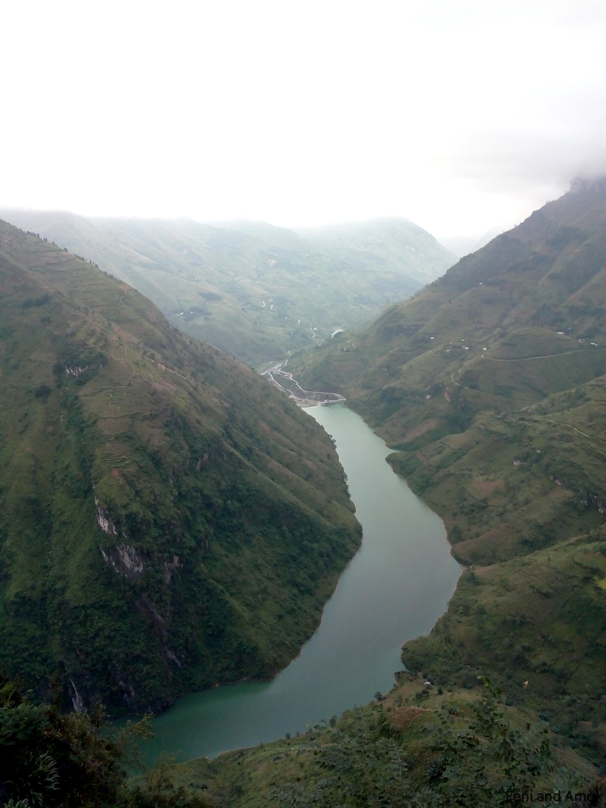
The first glimpse of the gorge was stunning. The ride along the pass did not disappoint, in spite of the expectations that have been set, having read so many reviews and blogs.

Winding roads, steep mountain sides, mist, clouds, karst mountains. It was indeed a treat to the eye, so tempting to stop every minute or so.


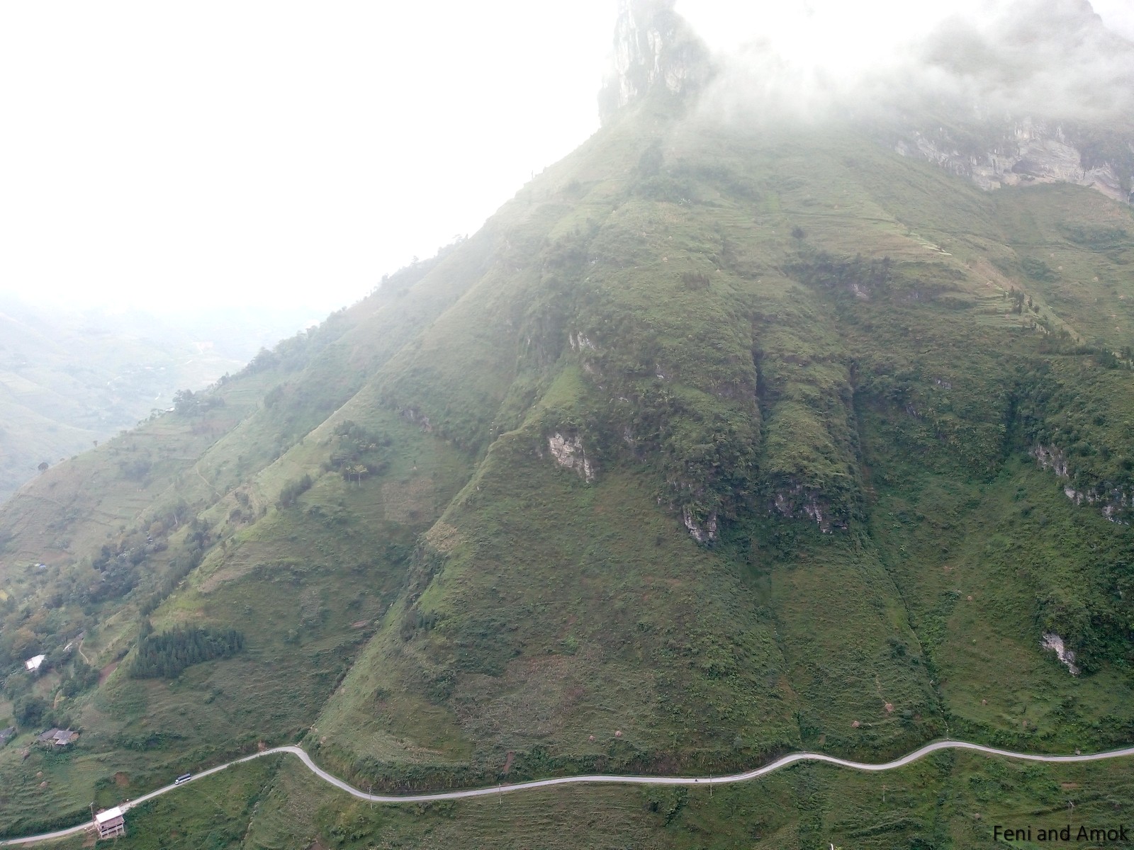
A monument commemorates the memory of workers who lost their lives during the construction of the 20 km highway between Dong Van and Meo Vac. About 1,500 meters above mean sea level, it is also called the 'Happiness Road', listed in the world's 'dangerous roads' list.


A look out point mid way helps travelers stop and take in more of the beauty of the mountains, snaking highway, gorge and river below.


The ubiquitous coal roasted eats, again! Just can't get enough of these yummies! We are on our way, off to Meo Vac.


Meo Vac turned out to be a sleepy little town, maybe the time of day - between 1 to 2 PM - added to the sleepiness. A quick lunch, a fill of petrol at a regular filling station, and we were off to Du Gia, about 80 km away.


Sometimes 80 km can be traveled in half hour, sometimes in one hour, sometimes in 2 hours. In the mountains of Ha Giang, however, 80 km implies about 4 hours of travel time.


The road to Du Gia turned out to be almost as spectacular as the Ma Pi Leng Pass. Well, not quite, but close. Not as well known, but more rugged and desolate in nature, the quality of roads were not at all as good, and we experienced frequent changes in weather. Clouds came down to ground level every now and then, the sun had given up trying to shine, almost zero traffic, super landscapes.


Villages were visible in some of the valleys far below.


It gets dark relatively early in the mountains. Four hours to travel 80 km. Disappearing sun. Clouds on the roads. We had to make it to Du Gia before it got real dark. We did, after a few quick stops to admire the deep gorge and river.


Accommodation for the night was at the Du Gia Backpackers Hostel (no homestay, for a change). Dinner was with a large group of travelers, followed by a game of pool. The Hostel had comfortable rooms, bunk beds and clean washrooms.


Ha Giang Loop Day 4 (Du Gia to Ha Giang):
Breakfast was at 8 AM, after which we rode on to Ha Giang. A leisurely ride through the Karst mountains, we went up and down as we crossed mountains and valleys.


Village folks carry heavy loads of corn for many kilometers. The loads are often 50 kg. Life has eased considerably once the 100 cc motos appeared, but many still walk it up and down across long distances.


At a colourful Hmong market in one of the valleys, where everything needed is bought and sold, ranging from food to clothes to furniture to utensils to chicken to pigs.


Some of the little roads on the Du Gia to Ha Giang route were in poor shape.

A pig is carried in a cage on a moto.


Mountains gave way to relatively flat land, and we also stopped at a hemp product workshop in Quan Ba district. Hemp yarn is used to make sheets, clothes and bags.


Quan Ba to Ha Giang was the last stretch, including a stop for Banh Mi sandwich on the way.


Last glimpses of the Karst mountains, as we leave the Karst Geopark and get into Ha Giang.

Up next is the 4 PM limousine to Ha Giang, turned out to be extremely comfortable. Reaching Ha Giang bus stop at about 10 PM, I used a Grab taxi to reach Ha Noi Guest House on Ma May Street. What an amazing six days.
Huge thanks to my guide Giang A Su for having made my trip so wonderful. Su is "Giang A Su" (Facebook and Facebook Messenger), and he can also be reached on +84.976.911.596 (Voice and WhatsApp). I wish Su the very best, and I look forward to visiting his home and coffee shop sometime in the future.
-=-=
Related posts - October 2018
StunningHa Giang Loop - Part 2 (this post)
-=-=-=